Cruising Ports: the Central American Route

Cruising Ports:

the Central American Route

Capt Pat Rains – Updated 2018-2023. Comprehensive nautical guidebook details all the yachts stops along Central America’s Pacific Ocean & Western Caribbean: Guatemala, El Salvador, Nicaragua, Costa Rica, Panama, also Mexico’s Gulf Coast, NW Cuba, Yucatan Channel, Belize, Honduras’ Bay Islands, Rio Dulce, Western Caribbean islands, Panama’s Caribe cruising grounds. Transiting the Panama Canal is the final chapter. 105 GPS-accurate charts, 290 color photos. Resource Directory lists all the marinas, fuel docks, boat yards, ship’s agents; websites, emails. Paperwork Cha Cha provides blank forms. GPS Waypoint List to the whole route. WX Radio Frequencies. No Covid regs. Award-winning guide is fully indexed. (Good companion to “Mexico Boating Guide.”)

$69.95 (+ S & H, Tax in CA)


Updates

Pg 42: San Juan del Sur, Nicaragua. Port Clearance: The new Immigration office is open, so boaters can clear in and out of Nicaragua here.


Pg 239: Panama Canal Transit Fees increased for yachts in January 2023 and will increase again in January 2024. See prices page 239.


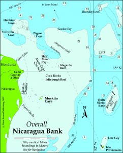
Pg 198: Replace the first paragraph with the following and update the chart: From the Cayo Vivarillo anchorage (15° 50’N, 83°19’W) we clear the south end of the Cayo and then head SE for 75 miles to an offshore waypoint at (15° 14.4’N, 82°16.6’W). This passes 2.5 miles south of the cay at the south end of the Cocorocuma Reefs. From the latter waypoint we turn SSE and lay a course 120 miles to the east side of Isla Providencia. Total distance is 209 n.m. We easily continue from Isla Providencia to Isla San Andrés.


Other titles from Point Loma Publishing

null

More Info

null

More Info

null

More Info

null

More Info

null

More Info